Charleston (Sullivan's Island) Lighthouse
Sullivan's Island, South Carolina - 1962 (1848**)

History of the Charleston (Sullivan's Island) Lighthouse
Posted/Updated by Bryan Penberthy on 2014-06-27.
Named after King Charles II, Charles Town, later shortened to Charleston in 1783, was established by English settlers in 1670. One of the Lords Proprietors, Anthony Ashley-Cooper, deemed it to become a "great port towne," a mission, in time, it would fulfill.
By the mid-1700s, Charleston continued to flourish, and became a bustling hub for Atlantic trade of the southern colonies. By the 1770s, it was the fourth largest port city, behind Boston, New York, and Philadelphia, and the wealthiest city south of Philadelphia.
Charleston played a major role in the American Revolution, having repelled a British attack on Fort Moultrie in June of 1776. The city would later fall to the British in 1780 and would be under British control until December of 1782.
The cotton plantations of the post American Revolution period fueled much of Charleston's growth and would take it into the 1820s. Around that time, the consensus around the state was that its laws were superior to those of the Federal Government. These feelings continued to escalate over the years.
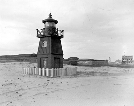
During this, Charleston remained one of the busiest ports in the country, and to guide vessels over the Charleston Bar into the port, construction of the lighthouse began in 1848. A red square tower standing atop four brick piers was erected about 300 yards to the south-west of Fort Moultrie. A fixed white light emanating from a sixth-order Fresnel lens provided just over ten miles of visibility.
With the onset of the Civil War, most navigational beacons of the south were darkened for fear of their use by Union troops. When it looked as though the location would fall, retreating Confederate troop were instructed to destroy the assets.
In port towns and along the seaboard, lighthouses were highly valued. Like the Cape Lookout Lighthouse in North Carolina, and the Hunting Island Lighthouse in South Carolina, the Sullivan's Island Lighthouse was destroyed during the Civil War.
After the surrender of forces in Charleston in 1865, a temporary skeletal light was established, against the owner's wishes, on the roof of a private house on Sullivan's Island. This light and the Weehawken lightship, which marked the wreck of the USS Weehawken, provided guidance into the harbor.Congress appropriated $15,000 on July 20, 1868 to re-establish the range lighthouses destroyed during the Civil War. In order to purchase land on Sullivan's Island, legislative action was required to gain clear title and cessation of jurisdiction. While waiting, time ran out on the appropriation and it was returned to the Treasury on July 12, 1870.
Congress had a $10,000 appropriation made on March 3, 1871. Ideally, the Lighthouse Board wanted to construct a pair of range lights on Sullivan's Island, however, to acquire a site there would have required additional legislation to be passed causing a delay, and it was unclear if the law would pass.
As the Federal government already owned land at Fort Moultrie, it was decided to place the lighthouses there. The Annual Report of the Lighthouse Board dated 1872 had the following descriptions of the range lights:
The front beacon is a frame structure resting on the parapet the fort. The rear one is an open-frame square pyramid. The dwelling is detached. The beacons and dwelling were finished in June, and the lights exhibited July 15.
Additional details in the report stated that they were painted red, and the Weehawken light vessel was discontinued on the same night as the lights were exhibited. A few days later, it was withdrawn from its post.
 Sullivan's Island Range Lighthouses (Courtesy Coast Guard)
In 1878, the front range lighthouse was moved from the parapet to the glacis of the fort, roughly 1,300 feet south of the rear light. It was mounted upon brick piers, giving it a focal plane of 20 feet above high water.
The following year, so that the lights were distinctly visible from the south channel, the front range beacon was raised six feet by being placed upon a brick basement, which was set up as an oil room.
Sometime over the years, the color of the front range lighthouse was changed to white, however, in 1883, it was painted once again and given the color of red. To accommodate the changing channel, the front range was moved 12 feet to the west and put on a wooden tramway in 1886.
Changes to the range lights came in 1888 and 1889. The front range beacon was moved 55 feet to the west, and an additional front range beacon was established, creating two sets of range lights by sharing the rear range tower.
The first range guided vessels through the South Channel, whereas the second range guided vessels through a channel between the shore and the south jetty, which was under construction. In the Annual Reports of the Lighthouse Board, these sets of range lights became known as the Sullivan's Island Range Lighthouses.
In 1890, and additional light, described as a "tubular lantern light" was established in the vicinity. It was detailed in the Annual Report of the Lighthouse Board for that year as follows:
521. Sullivan's Island Cove Pierhead, south end of Sea-View Railroad Bridge, South Carolina - A beacon light was set up on the south end of the trestle bridge of the Sea-View Railroad Company, to mark the channel through the waters of the cove. It was lighted on July 31, 1889. It is in good condition.
Additional request in the Annual Report of the Lighthouse Board called for an oil house for the Sullivan's Island Range Lighthouse. The following year, some addition work around the station was done, and a 9'x11' oil house was erected.
By 1892, the abandoned railroad bridge that the Sullivan's Island Cove Pierhead light was established on, was falling apart. As the wood of the trestle was never sheathed, ship worms had bored into and weakened much of the trestle. A new structure was put up the following year, and the light moved to that.
On May 20, 1899, the Sullivan's Island east and west range lights were renamed to the South Channel Range Lights. The range lights at Sullivan's Island were decommissioned in 1933, leaving the Morris Island Lighthouse to mark the way.
Due to the constant erosion at Morris Island, the Coast Guard opted to automate the lighthouse in 1938. At that time, the first-order Fresnel lens was removed, and replaced it with a smaller fourth-order lens due to the light's diminished importance.
At that time, the keeper's dwelling was sold and removed from the shrinking island as well. To try and reinforce the structure, a wall of interlocking metal plates was installed around the base of the tower, however, by the late 1950s, the Morris Island Lighthouse looked as though it would succumb to the ocean.
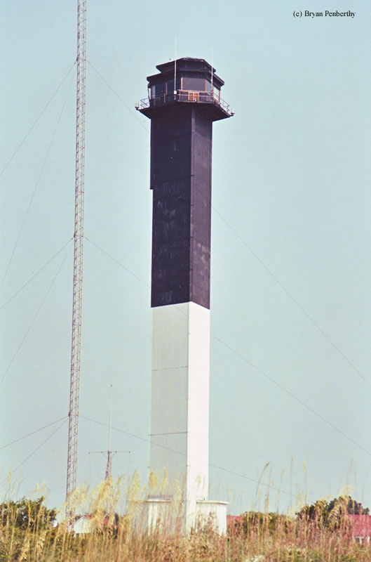
To continue to mark the Charleston Harbor, construction of a new lighthouse had begun in 1960 on the northern side of the harbor. As the federal government had established a lifesaving station on the island in 1895, it was decided to use that location for the lighthouse.To help the new lighthouse stand strong against hurricane force winds, it was given a unique triangular shape, capable of withstanding 125-mph winds, by its architect, Jack Graham of the U.S. Coast Guard.
After the design, Jack Graham left the Coast Guard, and never knew that his design was used in the construction of the lighthouse, until he saw the completed tower in Motor Boating magazine in August of 1962.
A solid concrete foundation serves as the base to which the skeleton of steel girders is attached. Over the steel girders are aluminum panels to give the lighthouse a skin. As it was the last federally constructed lighthouse in the United States, it does have some unique aspects.
To get to the top of the lighthouse, personnel can take the elevator, a feature Graham persuaded the Coast Guard to include due to the high number of accidents on lighthouse steps. It is the only lighthouse in the U.S. that includes an elevator. Another unique feature of the lighthouse, as it has offices, is air conditioning. And if the lighthouse should lose power, a generator at the base of the structure ensures the lamps stay lit.
When the Sullivan's Island Lighthouse was first completed, it was given a unique red/orange and white paint scheme. Many of the locals complained of the combination, which was later changed to its current color scheme of black and white. The keeper was housed in the old U.S. Lifesaving station dwelling.
The Sullivan's Island Lighthouse was first illuminated on June 15, 1962 and was proclaimed to be "one of the most powerful lighthouses in the Western Hemisphere." Its beam was produced by six separate lights mounted on an aluminum base, which weighed 1,800 pounds. The six lights produced an amazing 28 million candlepower which was said to be visible for 70 miles at sea.
Many neighbors complained of the beam, and due to the dangers associated with servicing the lamps, due to its intense heat, the light's output was cut back to 1.5 million candlepower in 1972. Even with this reduction, the light is still visible for 26 miles on a clear night.
The U.S. Coast Guard automated the lighthouse in 1975, removing the keeper. In 1986, the National Park Service took over most of the 1895 lifesaving service property for use as temporary housing, offices, and storage, however, they did not get ownership of the lighthouse.
As the Charleston (Sullivan's Island) Lighthouse was the last lighthouse to be built by the federal government, it has historical significance. To ensure its preservation, the National Park Service sought to acquire it.
The National Park Service had its wish fulfilled on May 29, 2008, when Chief Boatswain's Mate Andrew White, the Coast Guard's officer in charge of aids to navigation, met with Bob Dodson, Superintendent of the Fort Sumter National Monument, to hand over the keys and the security code to the tower.
A formal transfer ceremony was held on November 9, 2008 featuring music and art, along with a ceremonial key transfer. Due to safety concerns, only the base of the tower was open to the public. Due to ongoing problems with the elevator, there are no plans to open the lighthouse to the public.
Reference:
- Annual Report of the Light House Board, U.S. Lighthouse Service, Various years.
- A History of South Carolina Lighthouses, John Hairr, 2014.
- Lighthouses of the Carolinas - A Short History and Guide, Terrance Zepke, 1998.
- "Designer of Sullivan's light gets some recognition," Jessica Johnson, The Post and Courier, January 15, 2009.
- "Sullivan's Island lighthouse," Brian Hicks, The Post and Courier, September 12, 2008.
Directions: In Mt. Pleasant, take SC703 south. You will cross Sawyer Memorial Bridge to Sullivan's Island. You will come to a stop sign, there will also be a sign to Fort Moultrie. Take a right onto Middle Street and follow it to Station 18 1/2. Make a left and look up. Please note that this lighthouse is closed to the public.
(Station is just like a street name)
Access: The tower is owned by the National Park Service. Tower closed. Grounds closed. But there is a lot of areas around where the tower is visible.
View more Charleston (Sullivan's Island) Lighthouse picturesTower Height: 140.00'
Focal Plane: 163'
Active Aid to Navigation: Yes
*Latitude: 32.75800 N
*Longitude: -79.84300 W
See this lighthouse on Google Maps.