Saybrook Breakwater Lighthouse
Saybrook, Connecticut - 1886 (1886**)

History of the Saybrook Breakwater Lighthouse
Posted/Updated by Bryan Penberthy on 2012-11-03.
The first lighthouse built to mark the mouth of the Connecticut River at Long Island Sound was the Old Saybrook (Lynde Point) Lighthouse completed in 1803. Due to an off-shore sand bar at the mouth of the Connecticut River, navigation into the river was difficult and dangerous. Although it was marked with buoys, they were of little help as the sand bar was constantly shifting.
To help with navigation, The U.S. Army Corps of Engineers constructed two breakwaters. The west breakwater was 2,750 feet long and was completed in 1875. At this time, the shipping channel was also dredged. The east breakwater was completed several years later in 1880 and stands at 2,300 feet long.
Congress appropriated $20,000 on August 7, 1882 for the construction of a lighthouse at the end of the breakwater. After it was determined that the amount was insufficient, a temporary light was put in place while additional funds could be secured. An additional $18,000 became available on July 4, 1884.
The foundation for the tower was laid in 1885 and construction of the Saybrook Breakwater Lighthouse was completed the following year in 1886. At this point, the Lynde Point Lighthouse became known as the Saybrook Inner Lighthouse, while the Saybrook Breakwater Lighthouse became known as the Saybrook Outer Lighthouse.
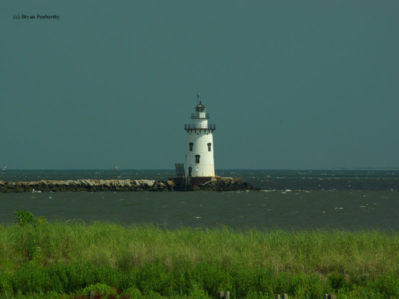
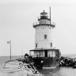
The lighthouse is a forty-nine foot tall brick-lined cast iron tower sitting atop a thirty-two foot tall concrete-filled caisson. The lighthouse, similar in design to the Latimer Reef Lighthouse in New York, consisted of a basement, four floors, and a watch room, all topped off by a twelve sided lantern room.
The first illuminating apparatus installed in the tower was seventeen oil lamps inside a fifth order Fresnel lens which displayed a fixed white light with a red sector. It was first lighted on the night of June 15, 1886. It was upgraded to a fourth order Fresnel lens in January of 1890. The oil lamps were upgraded to incandescent oil vapor in 1917.
The first fog signal was installed in 1889 consisting of a 1000-pound fog bell. Local residents long complained of the sound that it was replaced with a smaller 250-pound bell. A new striking machine was installed in 1899, but mariners still complained that the fog signal could not be heard until they were in sight of the breakwater. Because of this, mariners had requested an updated signal starting in 1930, but funds weren't available until 1936. At that time, two air-driven diaphragm horns were installed.
 Saybrook Breakwater (C.G.)
Like many of the other lighthouses on Long Island Sound such as the Beavertail Lighthouse, the Saybrook Breakwater Lighthouse took a direct hit from the Great Hurricane on September 21, 1938. The Great Hurricane of 1938 would start as a category 5 storm in the open Atlantic. But by the time it made landfall in the Northeast, it would be downgraded to a category 3.
The station was occupied by the Keeper, Sidney Gross, and his assistant, S. L. Bennett, when the storm hit. The keeper reported a slight breeze from the south at 2:00pm. Less than one hour later, they would have no way of knowing they would be in the midst of the worst hurricane to ever strike the Northeast.
As the winds began to pick up, the keeper attempted to exit the tower to secure some items on the platform, however, he could not push the door open due to the winds. By 4:00pm as the hurricane's intensity increased, the bridge to the breakwater and the platform were ripped away from the tower taking with it the station's boat. Less than a half hour later two kerosene tanks were swept away. One was a 1,500-gallon tank; the other was a smaller 600-gallon tank. The storm surge also carried away several of the boulders which made up the breakwater, some weighing several tons.
During the whole ordeal, the pair did their best to keep up against the elements. Fearing the waves crashing against the tower, they began to board up the windows only to be defeated by a massive wave which tore away the window flooding the engine room. By 5:00pm, the cellar was flooded with salt water which shorted out the batteries powering the fog signal and the electric light.
As a backup, Keeper Gross looked to employ the older incandescent oil vapor lamp to get the light showing again. Due to the constant pounding of the waves and the vibrations transmitted through the tower, the lamp's mantle fell apart. In a last-ditch effort to show the light, Keeper Gross was able to use an old oil wick lamp which he tended the rest of the night while fearing that the tower wouldn't withstand the punishment.
When the storm had passed, Keeper Gross looked over the damage and made an entry in the keeper's log: "Everything swept away by the hurricane except the tower." Gross and Bennett were lucky, they survived. Other keepers weren't as lucky. Keeper Walter Eberle would lose his life when the Whale Rock Lighthouse was swept away during the same storm.
The lighthouse was automated in 1959. In 1988 the Fresnel lens was removed and replaced with a 300mm modern optic and a 1,000 watt bulb showing a fixed white light with alternating green flash. The lighthouse was scheduled to be disposed of in April of 2007 under the National Historic Lighthouse Preservation Act of 2000. From what I can tell, the sale of the lighthouse was never completed.
The lighthouse became the symbol of Connecticut when it was featured on Connecticut's "Preserve the Sound" license plate.
Actress Katherine Hepburn once lived nearby at 10 Mohegan Ave in Old Saybrook. The property at one point was for sale on Sotheby's Realty website for $30 million.
Reference:
- The Lighthouses of Connecticut, Jeremy D'Entremont, 2005.
- Annual Report of the Light House Board, U.S. Lighthouse Service, Various years.
- The Lighthouse Handbook: New England: The Original Field Guide, Jeremy D'Entremont, 2008.
- America's Atlantic Coast Lighthouses (6th edition), Jeremy D'Entremont, 2005.
- "Old Saybrook Lighthouses: Life wasn't all that romantic for 'keepers of the light'," Ted Levy, Shoreline Times, July 28, 2011.
Directions: From Highway 154, head east on Nibang, which will change names to Sequassen Ave. From Sequassen Ave, head south on Neponset Ave. From here, you can see the Saybrook Breakwater Lighthouse, as well as the Old Saybrook (Lynde Point) Lighthouse.
Access: Lighthouse is closed. I am unsure if the breakwater is open for walking. A search provided no definitive answer.
View more Saybrook Breakwater Lighthouse picturesTower Height: 49.00'
Focal Plane: 58'
Active Aid to Navigation: Yes
*Latitude: 41.26320 N
*Longitude: -72.34286 W
See this lighthouse on Google Maps.