Sakonnet Point Lighthouse
Little Compton, Rhode Island - 1884 (1884**)

History of the Sakonnet Point Lighthouse
Posted/Updated by Bryan Penberthy on 2013-01-19.
As early as the late 1700s, the area around what is today Little Compton, Rhode Island was a fledgling port featuring fishing and farming as ways of life for the settlers. By the late 1800s, Sakonnet Harbor was much more developed and had a distinguished fishing fleet.
Little Cormorant Rock and several other submerged rocks and ledges sit several hundred yards offshore from Sakonnet Point making the area very dangerous for those vessels wishing to enter the harbor. To remedy the danger, the Lighthouse Board sought to establish a lighthouse to mark the area. For the project, Congress appropriated $20,000 on August 7, 1882.
The Lighthouse Board chose Little Cormorant Rock as the location for the lighthouse, and by 1883, construction of the caisson was underway. By late autumn, the iron caisson was filled with concrete and capped off. Installation of the superstructure would have to wait as unrelenting weather would put the project on hold until spring.
Construction crews resumed work in the spring of 1884. BY October, the four-story brick-lined cast iron tower was complete. The first floor of the tower housed a kitchen and living area. The second and third floors comprised bedrooms, and the fourth floor served as a combined watch / storage room. The Annual Report of the Lighthouse Board dated 1884 had the following entry:
127. Sakonnet (Little Cormorant Rock), mouth of the Sakonnet River, Rhode Island - The work at this important point was continued during the last season until the weather became too severe for further operations. At that time the iron pier had been set up in place and filled with concrete. The work was housed to protect it from the winter's storms, and operations ceased. At the opening of the present season work was resumed and carried forward to the completion of the iron work of the tower, lantern, and pier fittings. The brick work lining of the structure, the cistern in the cellar, and other parts of the station are also well advanced, and, if the weather does not prevent, the station will be lighted by the end of the present working season.
The fifty-eight foot tower sat atop of an eight-foot caisson, making the total height sixty-six feet tall. Inside the ten-sided lantern room, sat a fourth-order Fresnel lens which displayed a fixed white light interspersed with red flashes.
With Little Cormorant Rock exposed to the full fury of the Atlantic Ocean, many storms would ravish the tower. One such storm, the second reported hurricane of 1924 would pass over the lighthouse on August 26, 1924. Wind speeds over 75-mph would send waves crashing over to the top of the lighthouse. All the lower windows in the lighthouse were smashed along with the station's boats. But that would not compare to the Great Hurricane of 1938.
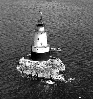 Sakonnet Lighthouse (Courtesy Coast Guard)
The Great Hurricane of 1938 would start as a category 5 storm in the open Atlantic. But by the time it made landfall in the Northeast, it would be downgraded to a category 3 with gusts reaching 121-mph. Like many of the other lighthouses in the area such as Beavertail and Whale Rock, the exposed location of the Sakonnet Lighthouse left it open to the full wrath of the hurricane.
The morning of September 21, 1938 started off pretty normal, but by late afternoon, the weather had changed. The winds had picked up and the sea began to rise. By 3pm, the waves had smashed the keeper's boats. By 4pm, the waves began to tear the station apart. The boat landing, an oil storage tank, and part of the rain shed went missing. The engine room had also flooded rendering the fog signal inoperative.
Things got worse by 5pm. Many of the doors were smashed in by the ferocious waves along with most of the windows. This led to a massive influx of sea water practically flooding the lower levels of the tower.
Around half past five, Keeper William Durfee went to light the lamps. While in the lantern, a tidal wave crashed over the tower knocking him to the floor. He likened the wave that crashed against the tower to a cannon going off. When the wave hit, it broke seven plates of the upper deck, which is fifty-six feet above the water.
When the storm had passed, the two keepers looked out at their surroundings to see massive devastation. Most of the cottages at nearby Sakonnet Point were missing, as well as their neighbor to the west, the Whale Rock Lighthouse. The lighthouse would sustain significant damage, including a major crack in the caisson.
Repairs were made to the station. The Coast Guard took over the lighthouse in 1939, and upgraded its lighting system to an incandescent oil vapor system utilizing kerosene.
The lighthouse would take another category 3 hurricane strike in 1954. Like the Great Hurricane of 1938, the tower took a relentless pounding of waves over several hours from Hurricane Donna. When it had passed, a crack in the base of the caisson was discovered, very similar to the one discovered after the 1938 hurricane.
The Coast Guard had estimated a cost of $100,000 to have the tower torn down and rebuilt. Rather than following that route, they decommissioned the light and abandoned it. By 1961, the tower went to auction. Carl Haffenreffer submitted the winning bid of $1,300, and was awarded ownership.
After maintaining the structure for many years, the Haffenreffer's found the cost prohibitive. In 1984, they offered the lighthouse to a nonprofit group if they could raise the necessary $75,000 required to restore the structure.
The Friends of Sakonnet Point Lighthouse, Inc. was formed and accepted the challenge. The group surpassed the required amount and raised $100,000 in little over a year. For their work, they were awarded the deed to the lighthouse. Once restoration was complete, the group had planned to relight the tower.
By 1992, the Coast Guard had secured the necessary equipment including the illuminating apparatus and solar panels to provide the necessary power. The stipulation was that The Friends of Sakonnet Point Lighthouse would have to come up with liability insurance should a maritime mishap transpire if the light malfunctioned. The group couldn't accept the culpability and the high insurance premiums, so they declined to have the tower activated.
Senator John Chaffee was able to help the Friends of Sakonnet Point Lighthouse in 1996, when he included an absolution clause in a 1997 appropriation bill freeing them of liability. After being dark for 43 years, the tower was relighted on March 22, 1997.
Several years later, the group had applied for a grant from the federal Transportation Enhancement Program, and in 2009 they were awarded $844,323. Along with the $200,000 they raised, the funds went towards patching, painting, and other additional repairs to the station.
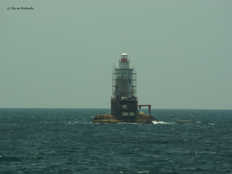
The work went out to bid in March of 2010, and the contract was awarded to the Joe Gnazzo Company of Union, Connecticut several weeks later. By June of that year, crews had set up scaffolding (as shown in the picture above) to start the sandblasting and replacement of the failing bolts holding the iron plates together. A three-part paint system was used on the plates consisting of primer, epoxy, and polyurethane.
The interior of the tower also received some work. The brick lining was removed exposing the iron plates, which were then sand blasted. After the sand blasting, the interior plates received the same three-part paint system as the outside. Once that was complete, the brick lining was reinstalled. The work was completed in late 2011.
Reference:
- Northeast Lights - Lighthouses and Lightships, Robert G. Bachand, 1989.
- America's Atlantic Coast Lighthouses (6th edition), Jeremy D'Entremont, 2005.
- Annual Report of the Light House Board, U.S. Lighthouse Service, Various years.
- The Lighthouses of Rhode Island, Jeremy D'Entremont, 2006.
Directions: The lighthouse sits offshore in the entrance to the Sakonnet River and Rhode Island Sound. A viewing area is available by following Highway 77 south to Sakonnet where the lighthouse will be visible.
Access: Tower closed to the public.
View more Sakonnet Point Lighthouse picturesTower Height: 66.00'
Focal Plane: 70'
Active Aid to Navigation: Yes
*Latitude: 41.45300 N
*Longitude: -71.20200 W
See this lighthouse on Google Maps.