Price's Creek Lighthouse
Southport, North Carolina - 1849 (1849**)

History of the Price's Creek Lighthouse
Posted/Updated by Bryan Penberthy on 2013-02-23.
As commercial activity flourished in North Carolina in the mid-1700s to the 1800s, Wilmington became one of the largest ports in the state. A hurricane struck the area on September 23, 1761 carving out a new inlet near the mouth of the Cape Fear River. This new inlet would shorten the travel time to the Port of Wilmington, and would become the preferred route of mariners.
Price's Creek Lighthouse, authorized in 1848, was one of eight lighthouses constructed during that time frame to increase the navigability of a twenty-five mile section of the Cape Fear River. Other lighthouses authorized by the same act were a set of range lights for Upper Jetty and Oak Island. Orton Point and Campbell Island were single lighthouses.
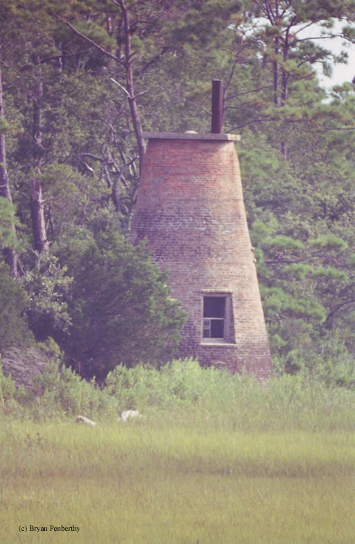
The twenty-foot brick tower, completed in 1849, served as the front range light. The base diameter of the tower was seventeen feet with walls three feet thick rising to a diameter of nine feet with two feet thick walls. It was constructed of bricks imported from England.
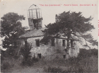
The rear range light was located about 700-800 feet back from the front range light and served as the keeper's quarters. It was a square brick structure measuring twenty-five feet by twenty-five feet, with a lantern on the roof giving the light an overall height of thirty-five feet. It was finished a year later in 1850. The Southport Times has a photo of the ruins of the Price's Creak rear range light. Lighthouse Digest has an archive photo of the Price's Creek rear range light as well.
The front and the rear range lights were originally outfitted with a series of eight lamps and focused with fourteen-inch reflectors. At some point, like most lighthouses, they were switched over to the more efficient sixth-order Fresnel lenses displaying a fixed white light. At some point in the 1850s, the tower was raised an additional six feet and capped off by a square platform visible in the picture above.
The first assigned keeper for the Price's Creek Range Lights was Samuel C. Mason, but he never took the position. John Bell would become the first keeper to actually serve at the lighthouse.
During the Civil War, the tower would serve as a Confederate signal station to relay communications between Fort Fisher and Fort Caswell. The Confederate Army used the lighthouses to navigate the river and identify batteries.
 Price's Creek Lighthouse courtesy Southport Times.
As the Civil War pressed on, the Union Army began to gain the upper hand, forcing the Confederates to retreat. As the Confederate Army retreated, they destroyed six of the eight lighthouses that were built along the Cape Fear River. Their rationale was that the destruction of the lighthouses would impede the advancement of the Union Army by making navigation along the river more difficult.
The only towers that made it through the war were the Price's Creek Range Lighthouses. Both were heavily damaged and taken out of service, but mostly still intact. They were abandoned by the federal government in 1861. By the turn of the century, hurricanes eventually claimed the rear range lighthouse reducing it to a pile of bricks, which local residents hauled away for use in new construction.
Today, the lighthouse stands on the private property of Archer Daniels Midland (ADM), a company that transforms crops into renewable products. The best view of the lighthouse is from the Southport / Fort Fisher Ferry. The lighthouse is in poor condition, with missing door, lantern, and windows, allowing the elements to enter the structure.
Many lighthouse preservation groups have written and called the Archer Daniels Midland Company asking them to either preserve the lighthouse, or let a group take over care for the lighthouse. However, from what I have read, there has been no response from the company. Its so sad that a corporation of that size cannot / will not do anything to preserve the town's heritage!
There are several photos on the web showing the original lantern room. The Lighthouse Digest has an archive photo showing the original bird-cage style lantern. The Southport Times has a different photo of the lantern room.
Reference:
- Lighthouses of the Carolinas - A Short History and Guide, Terrance Zepke, 1998.
- Annual Report of the Light House Board, U.S. Lighthouse Service, Various years.
- America's Atlantic Coast Lighthouses (6th edition), Jeremy D'Entremont, 2005.
- "Price's Creek - Visiting the Doomsday Light," Stephen Wilmoth, Lighthouse Digest, July 2005.
- "Price's Creek Lighthouse," Lisa Arnold, The Southport Times, October 5, 2013.
- National Park Service website.
Directions: The easiest way to view this lighthouse is via the Southport - Fort Fisher Ferry. The ferry travels right past the lighthouse. This shot was taken with a 500MM telephoto lens, and as you can see, it came out wonderful.
Access: The lighthouse sits on private property, and therefore access is restricted. The Outer Banks Lighthouse Society has in the past organized visits to the site with the owner's permission.
View more Price's Creek Lighthouse picturesTower Height: 26.00'
Focal Plane: 25'
Active Aid to Navigation: Deactivated (1861)
*Latitude: 33.93609 N
*Longitude: -77.98970 W
See this lighthouse on Google Maps.