Peninsula Point Lighthouse
Stonington, Michigan - 1866 (1866**)
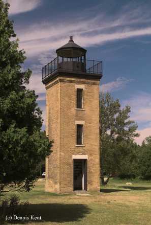

History of the Peninsula Point Lighthouse
This tower has been standing alone in the Hiawatha National Forest picnic section since 1959 when the accompanying keeper's quarters burned to the ground. This light was declared redundant in 1936 when the Minneapolis Shoal light was activated in Green Bay. The tower is open for visitors to climb.
Directions: From the Town of Stonington, take T Road (Highway 513) south 4 miles to the lighthouse.
View more Peninsula Point Lighthouse pictures
Tower Information
Tower Height: 40.00'
Focal Plane: Unknown
Active Aid to Navigation: Deactivated (1936)
*Latitude: 45.66800 N
*Longitude: -86.96600 W
See this lighthouse on Google Maps.
Tower Height: 40.00'
Focal Plane: Unknown
Active Aid to Navigation: Deactivated (1936)
*Latitude: 45.66800 N
*Longitude: -86.96600 W
See this lighthouse on Google Maps.