Newburyport Harbor (Plum Island) Lighthouse
Newburyport, Massachusetts - 1898 (1788**)

History of the Newburyport Harbor (Plum Island) Lighthouse
Posted/Updated by Bryan Penberthy on 2014-02-05.
Newbury Plantation, settled in 1635 by pioneers from Wiltshire England, was primarily made up of merchants and traders living by the water's edge and landowners and farmers living in the backland. As they were two vastly different groups with different needs, Newburyport split off as a separate town in 1764.
As Newburyport sits inland along the banks of the Merrimack River, vessels wishing to reach the harbor had to traverse the ever-shifting channels and sand bars that form at the mouth of the Merrimack River. Just to the south sits the nine-mile-long barrier island known as Plum Island.
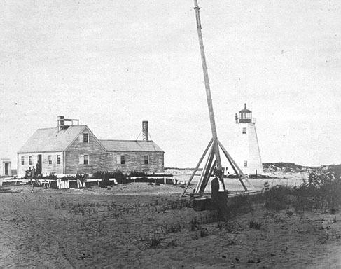 1793 Newburyport Harbor Lighthouse (Courtesy Coast Guard)
To distinguish the entrance to the harbor, mariners routinely set bonfires or erected poles that held torches on the northern end of Plum Island. In 1783, two day beacons were put up. The Marine Society of Newburyport, a predecessor to the U.S. Lifesaving Service, hired men to raise the lanterns to the beacons each night.
The day beacons were deficient and the merchants of Newburyport petitioned the General Court of Massachusetts for a remedy. In 1787 the court authorized the construction of "two small wooden lighthouses on the north end of Plumb Island," provided the construction costs didn't exceed "the sum of £ 300 lawful money." The cost of construction was financed by the merchants of Newburyport and totaled £266.
Constructed one year later, each 37-foot tower displayed a fixed white light on April 14, 1788. There is evidence in a Notice to Mariners dated April 1788 that the twin lights at Plum Island were perhaps the first time range lights were employed. The notice was as follows:
When any vessel shall fall into this Bay, or shall be forced in by distress of weather, and shall make these lights, she may run safely in, over Newbury Bar, observing the proper time of tide, and taking care to keep the two lights in one, until she gets within twice her length of the shore; then, directing her course by the beach, where is bold water, she may proceed, until abreast of the Western Lighthouse, where is good and safe anchorage in three fathoms of water.
The Lighthouses now bear East and West of each other, and are constructed as to be movable; and care will be taken, in case the Bar shifts, to place them in such a situation as that the foregoing directions will always be a good guide to mariners.
Range lighthouses appear as two lights on the horizon, however, when you line them up correctly, they appear as one atop the other, or one behind the other. A mariner would then know that they are on the correct path into the channel.
By the late 1700s and early 1800s, Plum Island became a popular resort destination. A small hotel on the island spurred the construction of a bridge. To service the island, a trolley line was extended and steamships would make frequent stops.
At the location where the Merrimack River and the Atlantic Ocean meet, the sands would shift often, therefore the lighthouses were built to be moved. They would be repositioned as necessary to keep proper alignment into the channel.
With the establishment of the United States of America, after Congress adopted the Constitution and the Bill of Rights, it passed the Lighthouse Act of 1789 in which the Federal Government assumed responsibility for all lighthouses and aids to navigation, of which there were only a handful at the time.
The General Assembly of Massachusetts signed the Plum Island Lighthouses over to the United States in 1790. President George Washington appointed Abner Lowell of Newburyport, locally known as "Uncle" due to his kindheartedness and generosity, as the first keeper with the lighthouse under federal control. Documents are unclear, but he may have kept the light before it being ceded to the United States.
The isolated station would also function as a signal station. The keeper would use flags to send messages, such as a vessel in distress or that a pilot was needed. During periods of reduced visibility, such as night or fog, a cannon was supplied to the keeper which he would fire to summon help.
On June 27, 1808, a violent tornado struck Newburyport. Both lighthouses were blown to the ground. To have the towers rebuilt, Congress appropriated $10,000 in February 1809.
Abner Lowell would serve as keeper until 1815. His son, Lewis Lowell took over at that time and would perish on December 1823 while on duty. That night was particularly cold, to keep the whale oil from congealing in one of the towers, he lit a charcoal fire under the lamp. As the carbon monoxide levels rose, he lost consciousness and died of asphyxiation. His son Joseph Lowell would take over, but would only serve for two years.
Government documents dated 1838 reveal that the lighthouses at Plum Island along with others in the state were in poor condition. The entry listed below, indicated that many lighthouses of Massachusetts were in need of rebuilding:
The establishments at Plum island, Squam, Straitsmouth island, Scituate, Plymouth, Billingsgate island, Monomoy, Point Gammon, Cape Poge, Tarpaulin Cove, and Gay Head, were found in a state of partial or complete ruin, and all require rebuilding.
In July 1838, Congress appropriated $4,000 for the rebuilding of the lighthouses; however, only $950.44 of the appropriation was ever spent. It appears that the towers were rehabilitated rather than rebuilt.
During December 1839, a severe gale struck Newburyport late on December 15 and into the morning hours of December 16. Reports indicate that the wharves were overflowed by high tide, many vessels in the harbors at Newburyport, Gloucester, and Salem sustained damage, but no lives were reported lost.
The following passage from Steamboat Disasters and Railroad Accidents dated 1840 describes the scene:
The keeper of the lights on Plum Island, describes the tide as having flowed quite across the island in a number of places, making many deep ravines, and causing many acres of meadow land to be covered with sand. The hotel and site, with almost all the buildings, were surrounded with one entire sheet of water, as well as the road leading to the bridge. The violence of the gale was such, as to remove many sand hills, forming at the same time many lakes and ponds. He also remarked that the whole eastern side of the island had washed away to an astonishing degree.
I.W.P. Lewis, engineer and Superintendent of the Lighthouse Survey, visited the station in 1843 and reported on the condition of the dwelling and towers. The dwelling, he noted, was "leaky on all sides, as well as the roof." He also noted that frequent winds would blow sand away from the dwelling, which could lead to the foundation being undermined.
Regarding the towers, he reported the following:
Towers. Two frame buildings, 36 feet high, resting upon logs and blocks of wood, laid on the surface of the sand hills, and both being movable to range with the shifting sand bar of the entrance to Newburyport harbor and the mouth of the Merrimac river; both towers dilapidated, decayed, leaky, and out of position, as to the bar channel, twelve months past.
In the report, he did stress the importance to the range lights providing clear direction into the channel:
The importance of ranging lights here, to give the true direction of the channel, can only be estimated by those acquainted with the hazardous nature of the navigation, which the many fatal shipwrecks on Plum island sufficiently testify.
Although they were designed to be moved as the channel over the Newburyport Bar changed, due to the height and weight of the towers, they were infrequently changed. I.W.P. Lewis recommended a new design for range lights that would allow the keeper to reposition them without aid.
The design he proposed was to set up two iron rails, each 108 feet long and parallel to the other, located about 100 feet apart at heights of twenty and thirty feet. Each rail would support an iron lantern which would contain three lamps, each with 14-inch reflectors. The cost for his innovative system was quoted at $1,315.91.
Stephen Pleasonton, the Fifth Auditor of the Treasury, and the man in charge of the nation's lighthouses declined to the implement the system. The notoriously tight-fisted auditor instead recommended both towers be repaired, new lanterns be installed, and they be moved into proper position to guide vessels into the channel.
A strange-looking smaller tower was erected on site in 1855 and would later become known as the "bug light." A year later, on August 8, 1856, one of the two towers was struck by lightning and burned to the ground. Rather than rebuilding the ravaged tower, the bug light was substituted with the remaining tower to serve as the range lights. That same year, the lamp and reflector system in the original tower was replaced with a fifth-order Fresnel lens.
In 1871, the lens in the original tower was upgraded from the fifth-order Fresnel to a larger fourth-order. The Annual Report of the Lighthouse Board for that year also stated that a new keeper's dwelling was under construction; however, I couldn't find any corroborating documentation to prove that. The report went on to state that the importance of Newburyport was sufficient enough to justify a new cast-iron lighthouse to replace the current wooden tower erected in 1816.
The Lighthouse Board recommended the new tower be mounted on a base of concrete, which was to be extended below the water line. The logic behind this was that if the tower should need to be moved in the future, there would be little more than an expense of a new concrete base to relocate it.
The lighthouses would be moved several times over the years. Due to sand deposits leaving the towers too far inland, in 1874, both towers had to be moved. The front light was moved 340 feet while the rear light was moved 455 feet, both to the east. To keep the site together, the keeper's dwelling and outbuildings were moved 100 feet to the south of the main lighthouse. That same year, to increase the effectiveness of the towers as day marks, the seaward side of the front lighthouse was painted black so that it would contrast against the rear lighthouse, which was white.
In an effort to stabilize the channel into Newburyport Harbor, The Army Corps of Engineers started construction of jetties in 1881. This work would continue over the next 18 years and conclude in 1899. When completed, the north and south jetties were 4,118 and 2,445 feet long, respectively.
During 1888, a survey was referenced to mark the property lines of the light station. The following year, the Annual Report of the Lighthouse Board had the following comprehensive entry regarding trespassers on lighthouse property:
61, 62. Newburyport Harbor, entrance to Merrimac River, Massachusetts - A cellar was made under the dwelling, 500 feet of plank walk from the dwelling to the tower and 114 feet of sand-catching fence were built, and a new ventilator was placed in the beacon. Some repairs were made. At Plum Island, in consequence of the changes in the channel of the Merrimac River and accretions at the northerly end of the island, the two light-houses were moved northerly from time to time, in all about 3,000 feet since 1827. The extent and boundary of the land belonging to the United States being in question, the United States attorney for Massachusetts, in 1887, after a very tedious, protracted, and laborious investigation, involving an examination of documents, reports, histories, and records, both State and colonial, back to the year 1639, submitted an elaborate report to the Department of Justice, in accordance with which a boundary line was surveyed pursuant to the Board's instructions of August 22, 1887, and the result transmitted to the Board January 6, 1888, since which date the action of the Department of Justice has been awaited regarding the boundary to be adopted. Trespassers have built a railway between the two lights, as well as a considerable number of dwellings in their immediate vicinity, which latter are increasing in number. It is important that measures be taken without further delay to define the extent and boundaries of the land belonging to the United States and to exclude trespassers therefrom.
The following year, the Lighthouse Board was questioning if the towers even served their purpose as a guide across the bar, and it appears that the property lines were still in question. The Annual Report of the Lighthouse Board dated 1890 had the following entry:
62, 63. Newburyport Harbor, entrance to Merrimac River, Massachusetts - The position of the channel across the bar at the mouth of the Merrimac River has so shifted that these lights no longer serve as guide through it, for which purpose they would now have to be placed on Salisbury Point, on the opposite or northerly bank of the river. The channel, however, has repeatedly shifted, and as it is uncertain what position it will ultimately assume, it is not deemed advisable to select new sites for the lights until the jetties now being constructed for its improvement are completed. Meanwhile they may be of some service in guiding vessels to an anchorage outside the bar. The question of the extent and boundaries of the light-house land at this station has long been in dispute, and the action of the Department of Justice in the matter has been awaited since January, 1888. Slight repairs were made in the dwelling.
It appears that the boundary dispute was still not addressed as an entry in the Annual Report of the Lighthouse Board dated 1891 stated the Lighthouse Board was still awaiting action by the Department of Justice.
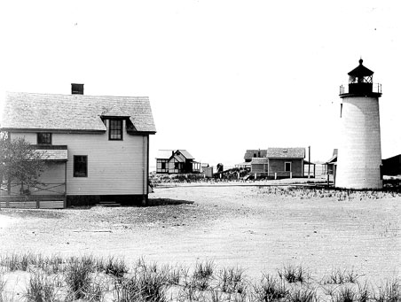 1898 Newburyport Lighthouse (Courtesy Coast Guard)
Other changes and repairs to the station were carried out over the years. In 1893, an oil house was added. A few years later, in 1895, extensive repairs were made to the structures including refreshing of the day marks added in 1874. Documents are unclear, however, in either 1896 or 1897, a new drain was laid, and the barn and fuel house were rebuilt.
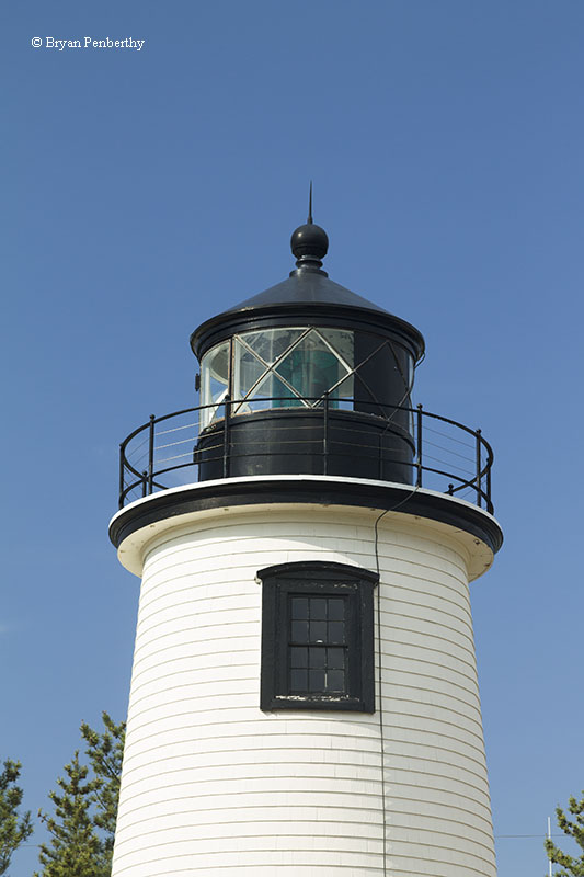
Although the Lighthouse Board recommended a cast iron lighthouse in 1871, a new conical wooden lighthouse was constructed in 1898 about 18 feet to the southeast of the original lighthouse. The fourth-order Fresnel lens in the old octagonal wooden rear tower was moved over to the new 45-foot tower, and lighted for the first time on the evening of September 20, 1898. That same year, a telephone line connecting the lighthouse with the Plum Island Life Saving Station was established.
Although it is unclear, at some point, the front range light of the Plum Island Harbor Light Station was discontinued. This most likely took place in 1898 as the new lighthouse was completed then, and the jetty project, started in 1881 was nearly complete which would have stabilized the entrance to the harbor.
Electricity was brought to the lighthouse in 1927 bringing an end to the kerosene era which had been used since 1877. For several years, the keeper of the Plum Island Harbor Lighthouse had additional responsibilities for maintaining the Salisbury Range Lights on the northern side of the Merrimack River as well as the Newburyport Range Lights on the waterfront.
After being attended to for 163 years, the Plum Island Lighthouse was automated in 1951. As the keeper's house was no longer in use, it was taken over by the Parker River National Wildlife Refuge and used for housing park officials.
The Coast Guard has maintained the tower over the years. Significant work was undertaken in 1993 which included repainting of the tower, replacing glass in the lantern, and new doors. In 1997, additional work was paid for by the Coast Guard, which included reshingling of the tower and new tar on the catwalk.
The Friends of Plum Island Light was formed in 1995 to care for the lighthouse. Over the years, volunteers from the group have spent countless hours maintaining the lighthouse as well as providing access to the tower during numerous open houses.
On May 10, 2003, the Coast Guard transferred ownership of the lighthouse to the City of Newburyport. The city immediately granted a ten year lease to the Friends of Plum Island Light.
Reference:
- America's Atlantic Coast Lighthouses (6th edition), Jeremy D'Entremont, 2005.
- Annual Report of the Light House Board, U.S. Lighthouse Service, Various years.
- The Lighthouse Handbook: New England: The Original Field Guide, Jeremy D'Entremont, 2008.
- The Lighthouses of Massachusetts, Jeremy D'Entremont, 2007.
- Various Government Documents, Federal & State Governments, Various dates.
- "Coast Guard Transfers Plum Island Lighthouse to the City of Newburyport," Jeremy D'Entremont, Lighthouse Digest, July 2003.
Directions: From US-1 in Newburyport, head east on Merrimac Street. This will change names several times. The first time, it will change to Water Street, and then to Plum Island Turnpike. Follow these streets 3.8 miles to the end. You will then head north on Northern Blvd and follow it to the end. It will be about 1.4 miles. At the end, you will see the Plum Island Light.
View more Newburyport Harbor (Plum Island) Lighthouse picturesTower Height: 45.00'
Focal Plane: 50'
Active Aid to Navigation: Yes
*Latitude: 42.81500 N
*Longitude: -70.81900 W
See this lighthouse on Google Maps.