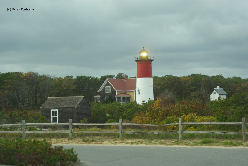
Nauset Beach Lighthouse
Nauset Beach, Massachusetts - 1923 (1838**)

History of the Nauset Beach Lighthouse
Posted/Updated by Bryan Penberthy on 2013-10-01.
The history of the Nauset Beach Lighthouse actually starts in 1836 when 21 Eastham area residents petitioned the Boston Marine Society requesting relief from vessels being lost offshore to the dreaded Nauset Bars. Within the Boston Marine Society, a committee was formed to study the request and determined that a light would be beneficial.
Congress appropriated $10,000 for the construction of a light station on March 3, 1837. Nearly five acres of land was purchased from Benjamin H.A. Collins of Eastham on September 14 for $150. The location that was selected was roughly halfway between the Highland Lighthouse to the north and the twin lights at Chatham to the south.
To differentiate between the lighthouses to the north and south, a unique design was selected. Three conical masonry lighthouse towers standing fifteen feet tall and spaced 150-feet apart were erected. To enhance the station, a brick keeper's house, a kitchen addition, an outhouse and a well were also constructed at that time. It was felt that since there was a single light to the north and twin lights to the south, having three lights at this location would distinguish it.
Mariners soon nicknamed the trio of towers "The Three Sisters of Nauset." It was said that the white towers with black lanterns resembled three demure ladies in white dresses with black hats. By 1892, erosion was threatening the sisters.
To remedy the situation, three new wooden towers were constructed 30-feet to the west of the masonry towers. The "Three Sisters" lighthouses would remain in use until 1911, when it was deemed a single lighthouse with a flashing beacon would be enough for mariners to ascertain their location.
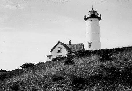 Nauset Lighthouse circa 1923 (Courtesy Coast Guard)
Starting in the early 1900s, the Lighthouse Board began its cost cutting measures reducing the number of "twin lights." Ten miles to the south stood the twin lights at Chatham. In 1923, it was deemed that two lighthouses at that location were not needed and at the same, the remaining "sister" in Nauset was in poor condition.
To replace the aging sister, the Lighthouse Board had decided that the north tower of the twin lights at Chatham would be moved to Nauset. Because it was constructed of cast-iron, disassembly was as simple as unbolting the plates and transporting them to the north. Once on location, it was reassembled upon a concrete pad to ensure its stability and lined with yellow brick. It became known as the Nauset Lighthouse or Nauset Beach Lighthouse.
To outfit the tower, the fourth-order Fresnel lens was moved from the old wooden tower and installed. To complete the station, the 1875 keeper's cottage was moved inland closer to the tower. At this time, the wooden lighthouse was sold to a local named Albert Hall, reportedly for $10, who constructed a single story addition and called it the "Beacon."
The 48-foot cast-iron tower would stay white until 1940 when the upper half was painted red to give it a distinctive daymark. Little did the Coast Guard know that painting the lighthouse would create an iconic symbol for the whole Cape Cod area. The lighthouse image has been used on countless items including license plates and potato chip bags.
The Coast Guard automated the lighthouse in 1955, and in the process, sold the keeper's house to a private party. The fourth-order Fresnel lens was replaced in 1981 by aerobeacons, and the characteristic of the light was changed to alternating red and white flashes. The Cape Cod National Seashore's visitor center on Route 6 in Eastham now displays the Fresnel lens.
In 1981, freelance writer and editor, Mary Daubenspeck purchased the old keeper's house. She would go on to write a book about her experience living at the lighthouse called Nauset Light: A Personal History.
Erosion would continue to plague the location. In 1991, the area was affected by the "Perfect Storm," a nor'easter that absorbed Hurricane Grace and struck on Halloween. During this storm, massive sections of the cliff were lost. All told, over the years 1991 to 1994, 30 feet of the bluff was washed away just east of the lighthouse.
As it did nearly 100 years previous in 1892, erosion would once again threaten a lighthouse at Nauset Beach. By 1993, the Coast Guard had planned to decommission the structure, but relented after hundreds of letters arrived at the Boston Headquarters suggesting the structure be moved.
Around that same time, several locals formed the Nauset Light Preservation Society (NLPS) in an effort to save the iconic structure. The Coast Guard had agreed to support the group's efforts and in 1995 granted the NLPS a five-year lease for the lighthouse.
After discussions with the Cape Cod National Seashore, a suitable location was chosen in April of 1996. At that time, the lighthouse was 43 feet from the cliff's edge. By late August / Early September, Hurricane Edouard would cut that distance down to 36 feet. Although it never made landfall, it lashed the Cape Cod shoreline for hours as it moved at a slow pace. This continual churning of the sea over several hours washed away major sections of the coastline.
In September of 1996, a contract was signed with International Chimney Corporation of Buffalo, NY to move the historic lighthouse to safety. The team of International Chimney Corporation and Expert House Movers has previously moved several other lighthouses, most notably the Block Island Southeast Lighthouse in Rhode Island in 1993, and the Highland (Cape Cod) Lighthouse to the north in Truro, Massachusetts in June of 1996.
By November of 1996, site preparations which included grading, excavation, and construction of a site access road had already taken place. Foundations for the tower and oil house were poured as well. At this time, the oil house was moved to a temporary location on November 9.
To prepare for moving the lighthouse, excavation took place to expose the foundation. Holes were drilled in the foundation to allow steel beams to be driven through it. On November 15, during freezing winds and snow, ten jacks would lift the 90-ton tower and transfer its weight to dollies hitched to a truck.
The truck pulled the lighthouse to its new home on November 16, 1996, a distance of 336 feet from the old location. Over the winter of 1996, many other maintenance items were taken care of. These included exterior renovation and painting, installation of a new railing, and brick work around the foundation. The lighthouse was relighted at a gala event attended by nearly 2,000 people on May 10, 1997.
After the tower's move, a red and white stake was placed in the ground to mark the former location of the lighthouse. By 2003, erosion had brought the edge to within three feet of the stake.
After several years of negotiations, Mary Daubenspeck donated the old keeper's house and existing site to the National Park Service to allow the station to be whole once again. Her only condition was that she be allowed the right to live in the house for another 25 years. Before the move on October 27, 1998, the house was 23 feet from the edge.
The Coast Guard signed over ownership of the lighthouse to the Cape Cod National Seashore. A partnership agreement between the National Park Service and the Nauset Light Preservation Society was signed in 2004 allowing the NLPS to operate the lighthouse as a private aid to navigation. The agreement also specifies that the NLPS will be responsible for all maintenance to the tower and oil house going forward.
Directions: From US-6 in North Eastham, take Nauset Road south and make a left onto Cable Road. Follow Cable Road east to the end. At the end of Cable Road, make a left onto Nauset Light Beach Road and you will immediately see the light on your left.
Access: Grounds open. Tours are available through the Nauset Light Preservation Society. Check their website for dates and times.
View more Nauset Beach Lighthouse picturesTower Height: 48.00'
Focal Plane: 102'
Active Aid to Navigation: Yes
*Latitude: 41.86000 N
*Longitude: -69.95300 W
See this lighthouse on Google Maps.