Marshall Point Lighthouse
Port Clyde, Maine - 1857 (1832**)

History of the Marshall Point Lighthouse
Posted/Updated by Bryan Penberthy on 2017-03-27.
During the 1800s, Port Clyde was a busy harbor. Shipbuilding, granite quarries, tide mills for sawing timber, and fish canneries all occupied the harbor. The Marshall Point Lighthouse was established in 1832 to mark the entrance to the Port Clyde Harbor.
Nearby Hooper Island, sometimes called Hupper Island, provided protection from Muscongus Bay and the open Atlantic Ocean. To establish a light to mark the entrance to Port Clyde Harbor, as well as provide a light for ships passing to the west into Muscongus Bay, Congress appropriated $4,000 on March 3, 1832 to establish the Marshall Point Lighthouse.
A suitable location was found at the southernmost point on the St. George peninsula. Four acres of land was purchased from Samuel Marshall for $120. As the light was only intended to mark the harbor, and not as a coastal light, Stephen Pleasonton, recommended that the height of the light be 20 feet, and that the lanterns that had been replaced at Franklin Island and West Quoddy Head, could be used for the Marshall Point and Browns Head lights.
When completed, the lighthouse was 20 feet tall, from the ground to the lantern deck. At its base, the tower was 17 feet in diameter, and tapered to nine feet at the top. Atop the rubblestone tower was a seven-foot-tall wrought-iron lantern, which held seven lard-oil lamps backed by 14-inch reflectors. Built adjacent to the tower was a one-and-one-half-story stone dwelling measuring 20 by 46 feet. The cost of the station was $2,973.17.
At that time, keeper positions were typically tied to political affiliations or military service. The station's first keeper was a veteran of the War of 1812 named John Watts. He served from 1832 to 1835. That year, his son Joshua took over and served until 1839.
Lieutenant Thomas J. Manning was ordered to survey the lighthouses of the first district in 1838. In his report, he states that he had limited time to gather information. This is evidenced by one line status for Marshall's Point - "In Good Order."
A more detailed report was ordered several years later. Isaiah William Penn Lewis, or I. W. P. Lewis as he was more commonly known, produced a report detailing the condition of the many lighthouses in New England. His report detailed the poor condition of the tower:
Tower of rubble masonry, nineteen feet high, laid up in bad lime mortar, yet soft and penetrable with a knife; base resting on the uneven surface of a ledge; walls cracked, and joints of masonry open to the weather; pointing all scaled off; roof, soapstone slabs, loose and leaky; interior of building covered with ice in winter; wood work defective.
The condition of the dwelling was just as bad:
Dwelling-house of rubble stone, laid up in lime mortar; roof shingled; walls cracked and leaky; roof leaky; windows leaky; chimneys very smoky; three rooms on the first floor and three chambers in the attic; no rain-water cistern; no boat; well dry in summer; establishment well kept, but entirely out of repair.
The tower was still in poor condition during an 1850 inspection. Two years later, the Lighthouse Board was established and immediately started to upgrade all the infrastructure. With that, they recommended in 1855 that the Marshall Point Lighthouse be replaced. On August 18, 1856, Congress appropriated $5,000 for the task.
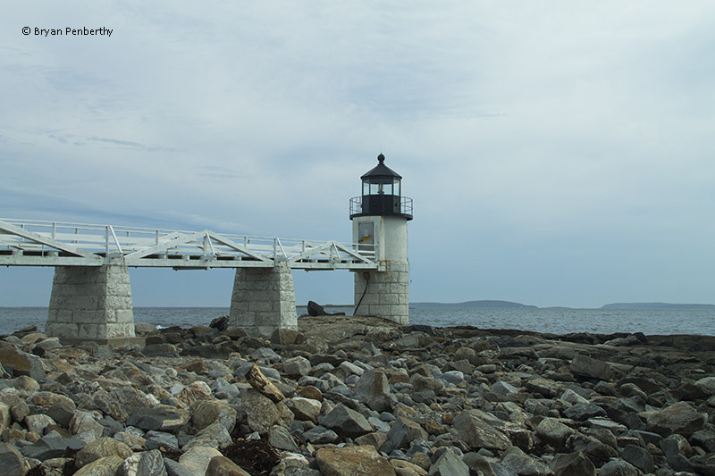
The current tower was built in 1857 and stands 31 feet tall. The lower half of the tower is granite while the upper half is brick. The tower was outfitted with a fifth-order Fresnel lens.
By 1882, the keeper's dwelling was in poor condition. The Annual Report of the Lighthouse Board for that year had the following entry:
36. Marshall's Point, entrance to Herring Gut or St. George's Harbor, Maine - The old stone dwelling was extensively repaired, the roof was reshingled and strengthened by fastening the beams to the plates with iron clamps; the old chimneys were removed, and two new ones were built; new windows and frames were put in, the cellar floor was cemented, and a new drain built; and the first story was renewed with new floorings, doors, and frames, and pantry. A room on the second floor was partitioned off, and the ceiling and plastering were partially renewed and repaired. The exterior walls were repainted, and all the wood-work was repainted with three coats of white paint. A new water-closet was erected and the fences were repaired.
Maintenance items were taken care of over the years. In 1889, the covered way was re-anchored to the six stone piers and the tower was repointed. In 1891, a barn and a fuel house were both rebuilt. The following year, a boathouse was built and in 1905, the oil house was rebuilt.
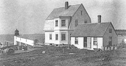
By 1896, the old stone keeper's dwelling was in poor condition. That year, it was demolished and a new wood-framed, Colonial Revival dwelling was built upon the foundation. At that time, some of the outbuildings were arranged to suit the condition of the new dwelling.
In 1898, a fog bell tower outfitted with a 1,018-pound bell sourced from the Buckeye Bell Foundry in Cincinnati, Ohio, was established at the station. A weight-driven clockwork mechanism would strike the bell every 20 seconds during times of fog. The fog bell was first placed into service on August 10, 1898. The fog bell was replaced by a fog horn in 1969, and in the 1980s, the bell was returned to the station, and is on display today.
As growing hostilities led to the United States to declare war on Spain in April 1898, many lighthouses were connected by telephone under the appropriation of national defense. The Marshall Point Lighthouse was connected by telephone to a hotel in Port Clyde.
 Marshall Point Lighthouse (Courtesy National Archives)
That same year, a weather signal tower was established at the Marshall Point Lighthouse. It became the keeper's job to fly various flags and pennants relaying weather conditions to mariners at sea.
The lighthouse was converted to electricity in 1935 and was automated in 1971. At that time, the fifth-order Fresnel lens was removed and replaced with a more maintenance-friendly plastic optic and battery backup system.
That same year, the station was outfitted with a long-range navigation (Loran) system, which was located in the newly-vacant keeper's house. Although Loran has been around since the 1940s, the Coast Guard took over its operations in the 1970s, but by the early 1980s, the technology was deemed obsolete. The Loran station was removed from Marshall Point in 1980 and the keeper's house was boarded up, allowing the property to fall into disrepair.
Soon thereafter, the Town of St. George took out a lease with the Coast Guard to keep the grounds out a developer's hands. In 1986, the St. George Historical Society sought to restore the house and raised the necessary funds. Restoration took place in 1988 and finish up by 1990.
The ground floor of the keeper's dwelling houses the Marshall Point Lighthouse Museum while the upper floor is rented to tenants. The museum opened in 1990 and saw a steady increase in visitors each year. By 1995, to add space to the museum, a replica of the summer kitchen was erected.
The Maine Lights Program, the predecessor to the National Historic Lighthouse Preservation Act of 2000, allowed ownership of 35 Maine lighthouses to pass to federal or state agencies, towns, or non-profit organizations, was signed into law in 1996. The Town of St. George successfully applied for and received ownership of the Marshall Point Lighthouse in June 1998.
The lighthouse was featured in the movie Forrest Gump. Forrest starts running, and runs all the way to the Santa Monica Pier. And from there, he heads east, and ends by running up the walkway to the Marshall Point Lighthouse. To commemorate the occasion, a picture of Tom Hanks at the lighthouse hangs in the museum.
Reference:
- Annual Report of the Light House Board, U.S. Lighthouse Service, Various years.
- The Lighthouses of Maine: Kennebec River to the Midcoast, Jeremy D'Entremont, July 9, 2013.
- Lighthouses of Maine, Bill Caldwell, 1986.
Directions: Take Highway 131 south into Port Clyde. Head east onto Drift Inn Road, then head south onto Marshall Point Road. This will lead you directly to the lighthouse.
Access: The lighthouse is owned by the Town of Port Clyde. Grounds, dwelling, and tower open.
View more Marshall Point Lighthouse picturesTower Height: 31.00'
Focal Plane: 30'
Active Aid to Navigation: Yes
*Latitude: 43.91741 N
*Longitude: -69.26120 W
See this lighthouse on Google Maps.