Grassy Island Front Range Lighthouse
Green Bay, Wisconsin - 1872 (1872**)

History of the Grassy Island Front Range Lighthouse
Posted/Updated by Bryan Penberthy on 2010-07-24.
 Grassy Island Lighthouse (Courtesy Coast Guard)
Grassy Island is a low-lying island in the middle of Green Bay, which blocked direct navigational access to the Fox River. If the area was to develop, ships would need a more direct route into the river. Money was approved for a lighthouse as early as the late 1830s, but with the island only several feet above the water line, it was feared that constant flooding would occur, and therefore the light was delayed.
A channel creation plan was developed, and dredging started in 1866. The dredging would take several years, but when it was completed in 1872, there was a two hundred foot wide shipping channel directly through the middle of Grassy Island. At this time, it was decided that the island would get a pair of range lights.
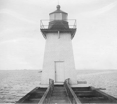
The two wooden towers would be built on the eastern side of the shipping channel. The idea was that mariners would line up the two towers. The height of the two towers varies with the Front Range light stands twenty-five feet tall, while the Rear Range light is thirty-five feet tall. When they appeared that they were on top of one another, then the ship was heading correctly into the channel. Also built at that time on the island were a two-and-a-half-story keeper's house, a boathouse, and a pier.
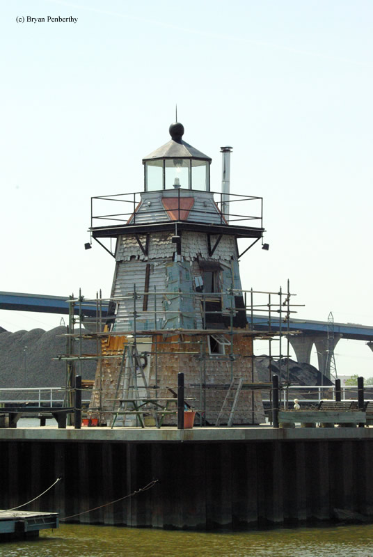
With traffic into the Fox River increasing, it was decided in 1966 that the shipping channel would be widened. This meant that the lighthouses would have to be moved. The Government was going to burn the towers down rather than moving them when the Green Bay Yacht Club stepped in. They were floated by barge to the grounds of the Yacht Club, where they sat for 30 years neglected. A new chapter is slowly being written in the history of the towers. The Green Bay Yacht Club moved the towers to their new permanent location on the grounds in 1999, and they have slowly begun restoration. The pictures that shot when I visited in 2007 show the towers in a state of restoration.
Reference:
- Great Lakes Lighthouses Encyclopedia, Larry & Patricia Wright, 2011.
- Wisconsin Lighthouses: A Photographic & Historical Guide, Ken & Barb Wardius, 2003.
- Lighthouses of Lake Michigan: Past and Present, Wayne S. Sapulski, 2001.
Directions: The lighthouse is located on the grounds of the Green Bay Yacht Club. From I-43, get off at exit 187. Make a left onto N. Webster Street and continue to the intersection. This will be N. Irwin Ave. Take this north, as it rounds the corner, the road will change names to Bay Beach Road. Continue on Bay Beach Road to the end. At the end will be the Green Bay Yacht Club and the Coast Guard Station. From the parking lot, you can get great shots of the lighthouse.
Access: Grounds open. Towers closed.
View more Grassy Island Front Range Lighthouse picturesTower Height: 26.00'
Focal Plane: 30'
Active Aid to Navigation: Deactivated (1966)
*Latitude: 44.53600 N
*Longitude: -88.00500 W
See this lighthouse on Google Maps.