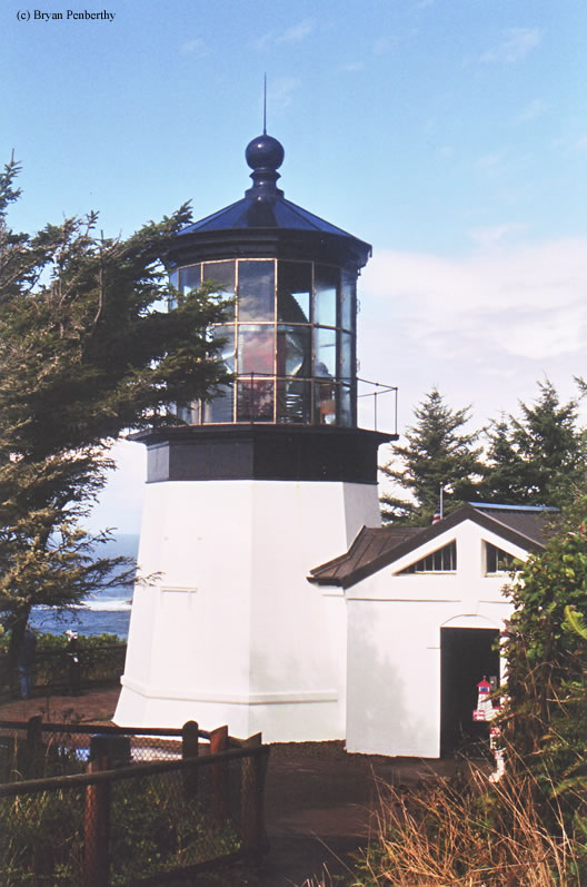
Cape Meares Lighthouse
Tillamook, Oregon - 1890 (1890**)

History of the Cape Meares Lighthouse
Posted/Updated by Bryan Penberthy on 2017-06-18.
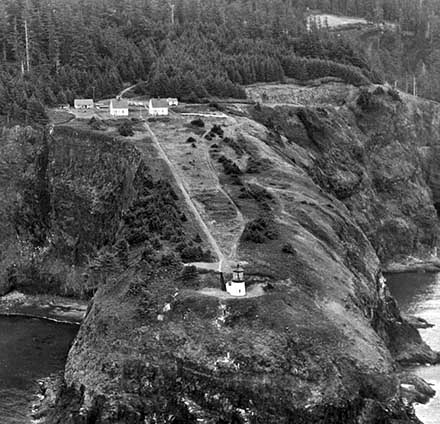
 Cape Meares Light circa 1955 (Courtesy Coast Guard)
Standing atop a rocky promontory more than 200 feet above the Pacific Ocean stands the Cape Meares Lighthouse. At a mere 38 feet tall, it is a stark contrast to the imposing cliffs below it.
Although Spaniards had explored the Pacific Northwest as early as 1493 and laid claim to the land, they had never settled it. As such, others began pushing in, and by the 1700s, the Russians were starting to settle in what is today Alaska. By the late 1780s, the area around Vancouver Island was being explored by Captain John Meares, formerly a lieutenant in the Royal Navy.
By May 1788, Meares and his men had arrived at Nootka Sound, on Vancouver Island. Using the port as a central location for his fur trading operations along the coast, Meares would later claim that Maquinna, chief of the Nootka people, traded him land for several pistols and some other goods. A claim Maquinna would deny, calling Meares a liar.
While in Nootka Sound, during the summer of 1788, Meares's group built the first non-indigenous vessel to be built in the Pacific Northwest - The sloop North West America. In that vessel, Meares sailed south examining the area and naming different land forms.
When Meares approached the mouth of the Columbia River, he was unable to tell if it was a river or bay, so he called it Deception Bay and named the headland Cape Disappointment to reflect his feelings. On July 6, 1788, Meares entered Tillamook Bay, which he called "Quicksand Bay." Soon after arriving, he turned to head back north. On his way out of Tillamook Bay, he named the point of land just south "Cape Lookout."
This name stayed with the point until the early 1850s when nautical charts were published and incorrectly placed the name Cape Lookout on a much larger point of land, about ten miles to the south. As time had passed before the error was realized, most mariners had already come to know the southern cape as Cape Lookout. Rather than correct the error, in 1857, George Davidson of the U.S. Coast Survey named the northern headland Cape Meares, in honor of its discoverer, forever affixing the name.
Many settlers came to the area in the 1840s and 1850s as prospectors returned from the gold fields in California and pioneers crossed the Coast Range to settle in the fertile Tillamook Valley. As the bay is protected from the open ocean, it became a harbor of refuge along the West Coast.
The area soon became known for its salmon canneries, dairy farms, cheese-making, and timber. The products were shipped from the area to various distribution points in California. As commerce increased substantially, improvements to navigation and the harbor were requested.
In 1886, the Lighthouse Board requested $60,000 for a lighthouse and fog signal near Tillamook Bay. As the sites at both Cape Lookout and Cape Meares were brought up as possibilities, civil engineer James S. Polhemus of the Army Corps of Engineers was sent to survey both capes.
The Annual Report of the Lighthouse Board for the year 1887 had the following entry:
Cape Meares, sea-coast of Oregon - The buildings proposed at this station are a low tower of cast-iron plates, two oil-houses of brick, two frame dwellings and a barn, the latter to include a shop and tool-room; also a large cistern, and a pipe line from the spring on the bluff back of the cape. As the cape is a part of a small piece of unsurveyed public land over which surveys will soon be extended, orders were given by the Government to have this site reserved from sale until after the survey is made and a light-house site is selected.
By early 1887, Cape Meares was recommended by Polhemus for the new lighthouse. Factors that had influenced his decision were a lack of vegetation and a promontory which projected seaward two to three hundred feet further than the Cape Lookout headland. Polhemus noted that any materials that needed to be shipped to the site would have to be landed in Tillamoook Bay and then hauled overland to the lighthouse site.
In the survey of Cape Lookout, Polhemus found that it was heavily timbered, hard to get to, and lacked a fresh water source. However, the Lighthouse Board kept Cape Lookout as a lighthouse preserve for a number of years. Finally, on September 3, 1935, the U.S. Lighthouse Service gave the property to the State of Oregon, who later established the Cape Lookout State Park.
That same year, engineer C.F. Powell of the Army Corps of Engineers drew up the plans and specifications for the station, which were approved in January 1888. Bids for construction of the station were advertised soon thereafter and opened on August 30, 1888.
On September 24, 1888, a contract of $2,900 was made with Charles B. Duhrkoop of Portland, Oregon for the construction of the lighthouse. Three days later, a contract of $7,800 was made with the Willamette Iron Works of Portland for the metalwork needed for the tower.
The largest contract was made on October 2, 1888, with Richard Seaman, a Portland contractor, for the construction of two brick oil houses, two keeper's dwellings, a barn, and cisterns. The contract amount was $26,000.
In 1888, the Lighthouse Board had recommended the construction of a four-mile long road to the nearest beach landing in Tillamook Bay. This was to be done in preparation of the building supplies that would need to be landed there and portaged to the lighthouse site.
Willamette Iron Works delivered the materials to Tillamook Bay on March 1, 1889, by coastal vessels. The sheet iron plates were then offloaded to a scow to be landed on the beach. As no work was ever done on the lighthouse road, a local logger was contracted to haul the materials overland by wagon to the lighthouse site. A long and laborious process.
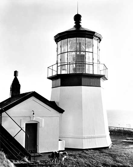
 Cape Meares Lighthouse (Courtesy Coast Guard)
Local Native Americans were hired to harvest timber and dig up the clay, which was then fired into bricks with a special kiln on site. Duhrkoop then supervised the construction of the tower, which, when complete, was encased in iron plates.
The eight-sided, one-ton, first-order Fresnel lens was manufactured in Paris, France by Henry LaPaute. The carriage, clockwork, weights, and other components weighed an additional ton. When completed, it was shipped around Cape Horn to the Pacific Ocean, and then up to Northern Oregon, where it was hoisted up the cliff face with a hand-operated crane made from spruce trees cut on the cape.
By November 28, 1889, all buildings at the station were complete and by December 23, 1889, the tower was complete and the lens and lamp were in place. Although the station was ready to be lit, the date published in the Notice to Mariners was January 1, 1890, so the station remained dark for a week.
The station's first principal keeper, Anthony W. Miller, lit the five-wick kerosene lamp for the first time on the night of January 1, 1890. The characteristic of the Cape Meares Lighthouse was a two-second red flash followed by a 60-second white flash. In 1910, the lantern was outfitted with incandescent oil vapor lamps, which burned cleaner and more efficient.
Although the lighthouse was complete, there were still a few additional items that needed completing that were noted in the Annual Report of the Lighthouse Board for the year 1890:
In order to complete the station, there is yet to be provided a suitable landing place for supplies somewhere on Tillamook Bay, and a road leading thereto. Fences and board walks about the buildings and towers are yet to be provided, also steps leading from the edge of the bluff down to the foot of the tower. It is thought that the unexpended balance yet remaining from the appropriation for this station will be sufficient for all this work.
By the following year, the fences and walks were completed. Several lines for the wagon road were surveyed and their construction costs were estimated. The "short beach route" was chosen as it was the most convenient and would add "materially to the development of the country." Of the $60,000 appropriation, there was still $9,000 left. It was estimated that the cost of the wagon road would be about $5,000.
The construction was stalled and the same request was repeated in 1892. Congress had given its approval for the road in 1893 and advertisements for the work were requested. Two proposals were received but were rejected as they were over the allotted amount. New proposals were solicited but again were deemed excessive.
Work on the wagon road to Tillamook City commenced in 1894. As all bids received were over budget, the work was done by hired labor and materials. The wagon road connected to an unfinished county and the Netarts Bay Road, which made the station accessible from Tillamook City.
In 1895, several construction projects were started, but couldn't be finished during the fiscal year due to poor conditions of the wagon road. The Annual Report of the Lighthouse Board had the following entry:
Cape Meares, south of Tillamook Bay, seacoast of Oregon - A work room attached to the tower, built of brick, was partly finished; a flight of iron steps, to lead from the level of the tower to the top of the bank, and a wood shed were begun, but it was impossible, on account of bad roads, to deliver all the materials at this station in time to complete the structure within the fiscal year. Everything is now delivered, and the work will be completed as soon as practicable.
Work was carried out on the wagon road in 1896. It was leveled, trees and roots were removed and gravel was spread. As a section of the road would become muddy, it was recommended to remove the trees on the south side of the road to allow the sunlight to shine upon it.
After the town of Bayocean was established in 1912, the keepers typically shopped there. In 1922, a trail was established to Bayocean at a cost of $4, 165.
The lighthouse was changed over electricity in 1934, which was provided by two Kohler generators. Shortly thereafter, the two brick oil houses were dismantled as they were no longer needed.
On April 1, 1963, the Cape Meares Lighthouse was replaced with an exposed DCB aero-beacon manufactured by the Carlisle & Finch Company. The beacon was mounted atop a concrete structure several feet away from the tower.
After lighting duties were transferred to the concrete structure, the Coast Guard had planned to remove the lighthouse and had already torn down the old workroom attached to the tower in 1960. Concerned citizens stepped in to voice their opposition. The Coast Guard soon relented and leased the property to Tillamook County on November 6, 1964.
With no one to watch over the vacant property, weathering and vandalism were soon rampant. Hippies would frequently be found living in the keeper's dwellings and four of the bull's eyes from the first-order Fresnel lens were stolen. Though an effort was made to recover the bull's eyes, the state did not have much luck.
Nearly 20 years later, their luck turned. Surprisingly enough, one of the bull's eyes was recovered during a drug raid in Portland, Oregon, nearly 90 miles away. A 1986 magazine article pleaded for the return of the other three, and over time, they were all returned.
On July 2, 1968, the Oregon State Parks Department took over the lease from Tillamook County. The iron-plated lighthouse was now covered with rust and the keeper's dwellings were ramshackle. As the keeper's dwellings were beyond saving, they were torn down.
The state was able to allocate funds for the maintenance of the property and in 1978, a replica of the workroom was built. The only difference was the entrance was the location of the entrance to the tower. It was placed on the south side, instead of the north side to better accommodate visitors. That same year, the tower was scraped and repainted. The tower officially opened to visitors on Memorial Day 1980.
By 1986, the Coast Guard had planned to discontinue the automated light on the concrete structure, but after a flurry of protests from Tillamook Bay's commercial fishermen, the Coast Guard relented.
Cape Meares Fresnel Lens Damaged
While the lighthouse was closed for the winter, sometime between the afternoon of January 9 and noon on January 10, 2010, an unknown vehicle drove down a blocked maintenance road and fired numerous shots at the Cape Meares Lighthouse. The rounds broke 15 windows and damaged numerous prisms that make up the antique first-order Fresnel lens. The vandals also damaged the surrounding grassy area with their vehicle. All told, the damage was estimated at $500,000.After a $5,000 reward was issued, Oregon State Police received a tip that led to the arrests of twenty-three-year-old Zachary J. Pyle and twenty-six-year-old David R. Wilks. Both were charged with first-degree criminal mischief, a class C felony, and four misdemeanor charges. The pair confessed to the damage, admitting that they were drunk at the time.
The men were given a creative sentence by Judge Charles E. Luukinen - three, 16-day sentences to be served each year at Christmas time and $100,000 in restitution. The sentence was structured to allow the men to keep their jobs and continue to make restitution. While handing down the sentence, the judge said, "Some people go to Hawaii for vacation and some people go to jail. The next three years will serve as a reminder, and you are going to get some time to contemplate that."
Less than six weeks later, Zachary J. Pyle was arrested again. His probation specifically prohibited the use of alcohol and drugs, of which he was on both when he showed up at the Tillamook County Sheriff's Office to claim property that was seized during the Cape Meares Lighthouse investigation. He was arrested for probation violation and driving under the influence.
In early 2014, the Coast Guard proposed a plan to discontinue the modern light that sat atop the concrete structure. After no comments were received, the light was discontinued on June 25, 2014, bringing an end to the 124-year history of the Cape Meares Lighthouse. Today, the lighthouse is part of the Cape Meares State Scenic Viewpoint and is surrounded by the Cape Meares National Wildlife Refuge. The lighthouse is opened for tours by The Friends of Cape Meares Lighthouse & Wildlife Refuge, Inc., a 501(c)3 nonprofit organization.
Reference:
- Annual Report of the Light House Board, U.S. Lighthouse Service, Various years.
- Lighthouses of the Pacific Coast: Your Guide to the Lighthouses of California, Oregon, and Washington, Randy Leffingwell, 2000.
- National Register of Historic Places, U.S. Dept. of the Interior, Various.
- Oregon's Seacoast Lighthouses, Jim Gibbs & Bert Webber, June 2003.
- "Vandalism does more than $50,000 damage to historic Cape Meares Lighthouse," Steve Beaven, The Oregonian, January 11, 2010.
- "Oregon State Police arrest two in connection with Cape Meares Lighthouse vandalism," Lori Tobias, The Oregonian, February 11, 2010.
- "One of men involved in Cape Meares Lighthouse shooting arrested on DUI," Lori Tobias, The Oregonian, February 10, 2011.
- "Vandals Strike Cape Meares Lighthouse Causing Half Million Dollars In Damage," Staff, Lighthouse Digest, March 2010.
- "Cape Meares Lighthouse Vandals Sentenced," Staff, Lighthouse Digest, March / April 2011.
Directions: In the town of Tillamook, take a right onto 3rd Street, go about 1.75 miles and make a right onto Bayocean Road NW. Follow Bayocean road for several miles until you see the cut off for Cape Meares Loop. Make a left onto Cape Meares Loop, and follow that into the park. From here, it was a short walk to the Cape Meares Lighthouse.
Access: The Cape Meares Lighthouse is owned by the U.S. Coast Guard and managed by the Oregon State Parks Department. Grounds open. Tower open in season.
View more Cape Meares Lighthouse picturesTower Height: 38.00'
Focal Plane: 217'
Active Aid to Navigation: Deactivated (1963)
*Latitude: 45.48600 N
*Longitude: -123.97800 W
See this lighthouse on Google Maps.