Cape May Lighthouse
Cape May, New Jersey - 1859 (1823**)

History of the Cape May Lighthouse
Posted/Updated by Bryan Penberthy on 2011-03-14.
There is documentation that shows that the English had intentions of building a lighthouse in the Cape May area dating back to 1785 when land was purchased from Thomas Hand II and conveyed to the Port of Philadelphia. However, no official records of a lighthouse being built in that area exist, despite an advertisement in a 1801 Philadelphia area newspaper claiming a lighthouse as an attraction in the Cape May area.
 Cape May Lighthouse (Courtesy Coast Guard)
The first documented lighthouse to mark the northern entrance to Delaware Bay was a 68 foot tall brick tower with a purported focal plane of 88 feet above sea level. Completed and first lit in October of 1823, it originally stood about 1750 feet to the west, an area which is now under water. Given the tower was surround by water during high tide, it was decommissioned on May 1, 1847.
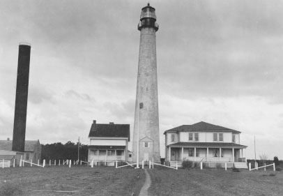
A new tower was built in 1847 on a bluff about 1760 feet inland from the 1823 tower on a two acre tract of land purchased from Alexander Whilden for $1150.00. The tower was built by contractors Samuel and Nathan Middleton and stood 78 feet tall. An 1852 report from the lighthouse inspector showed a laundry list of problems on the 5 year old tower. Items such as rough wood work, lack of paint in areas, rusty ironwork, and thin plate glass were just a few mentioned in the report.
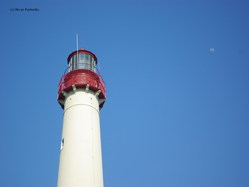
By 1857, Congress had set aside $40,000 for a new tower of first order at Cape May. The new tower was designed and constructed by several of the U.S. Army Topographical Engineers, notably Captain William F. Raynolds and Major Hartman Bache, which had designed and / or constructed several other New Jersey sea coast Lighthouses, namely the Absecon and Barnegat Lighthouses. When the new tower was completed, it would stand 157 feet tall, and would be outfitted with a first order Fresnel lens. Kerosene would be the fuel used to provide the light, which was visible for 19 miles. The tower first exhibited its unique flash on Halloween night, 1859.
The new keeper's dwellings were completed the next year in 1860. However, the Cape May Lighthouse, being a first order sea coast lighthouse employed three keepers. The Annual Report of the Lighthouse Board from 1900 reported that the lack of a suitable living quarters for the third keeper and his family was unacceptable and was hurting efficiency, and recommended construction of the third keeper's dwelling on site. It would take several years, but in 1903, a new keeper's dwelling was constructed.
The original 1847 tower was truncated in 1862 to avoid confusing mariners. The bottom ten feet of the tower was capped off and used for many purposes at different times, such as an ice house, and a stable. Eventually this storage shed met the same fate as the original 1823 tower, being lost to erosion. The area where the 1847 tower stood, is now underwater.
The tower, like most lighthouses, had its illumination upgraded over the years. In 1878, a new Funck style lamp was installed. Then in 1902, it was upgraded to an incandescent oil vapor lamp, and finally electricity in 1938. In 1946, the first order Fresnel lens was removed, and replaced with a modern DCB-36 beacon. The lens is now on display in the Cape May County Court House.
The ownership of the grounds surrounding the lighthouse were transferred to the state of New Jersey in 1964. The federal government then leased the dwelling and the grounds to the State of New Jersey in 1986, which in turn subleased them to the Mid-Atlantic Center for the Arts (MAC). The title of the lighthouse was officially transferred to the state of New Jersey in 1992. The MAC has been successful in applying for and receiving grants to on the ongoing care and restoration of the lighthouse. Today, the tower is open for climbing. 199 steps will get you to the top.
Reference:
- Down The Jersey Shore, Russell Roberts and Rich Youmans, 2003.
- South Jersey Towns: History and Legend, William McMahon, 1973.
- America's Atlantic Coast Lighthouses (6th edition), Jeremy D'Entremont, 2005.
- Annual Report of the Light House Board, U.S. Lighthouse Service, Various years.
- Guarding New Jersey's Shore: Lighthouses and Life-Saving Stations, David Veasey, 2000.
- New Jersey Lighthouse Society website.
- Annual Report of the Light House Board, U.S. Lighthouse Service, Various years.
Directions: Follow the Garden State Parkway south to Cape May. At the end of the Garden State Parkway, follow Route 633 (Lafayette Street) south into Cape May. At the end of Lafayette Street, make a right onto Bank Street and a left onto Broad Street. Broad will change to Jackson Street and West Perry Street. West Perry will change into Sunset Blvd. Follow Sunset Blvd to Lighthouse Ave. Follow Lighthouse Ave to Cape May Point State Park.
Access: Lighthouse tower and grounds open.
View more Cape May Lighthouse picturesTower Height: 157.00'
Focal Plane: 165'
Active Aid to Navigation: Yes
*Latitude: 38.93300 N
*Longitude: -74.96000 W
See this lighthouse on Google Maps.